Weenat app
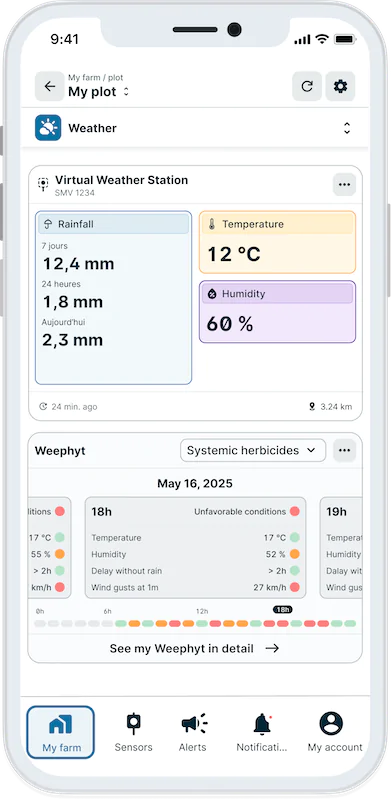
The Virtual Weather Station
A complete overview of your farm, down to the square kilometre
The Weenat Virtual Weather Station gives you access to reliable weather data, wherever you need it. Rainfall, temperature and humidity data, updated every hour, available directly in the Weenat app.

Rainfall

Temperature

Humidity

→ Do you need to monitor weather conditions across many remote sites?
→ Do you and your teams operate over a large area?
→ Do you want access to reliable weather data?
The Virtual Weather Station is made for you.
Deploy your network of Virtual Weather Stations in just a few clicks from your desk. Benefit from weather data recognized and validated by agricultural professionals.
Available immediately,
everywhere across your territory
Zero installation, zero maintenance
No equipment to order, install or maintain. Activation in just a few clicks in the Weenat app, from anywhere.
Hourly updates
Data updated 24 times a day. A slight delay of around 3 hours ensures a calibrated dataset resulting from multi-source aggregation.
Continuous history from day one
No data gaps, no battery failures. The complete history is available hour by hour; from the moment the station is activated.
Compatible with your DSTs
Activate your decision support tools from day one: the Virtual Weather Station continuously feeds your agronomic models with data – with no interruptions or gaps.
Square-kilometre precision
Spatially resolved data down to the square kilometre. Rainfall, temperature, and humidity reflect the actual conditions of each plot across your territory.
Everything in a single app
Virtual Weather Station, physical sensors, alerts, historical data and DSTs – all centralised in the Weenat app. A 360° view of your farm without juggling between tools.

The Weenat technology behind the Virtual Weather Station
Meteo Vision
The Virtual Weather Station is powered by Meteo Vision, the weather model developed by the Weenat teams. It combines several complementary data sources:
- Numerical weather models,
- Rain radars,
- Satellite observations,
- Data from reference stations.
The result: spatially resolved weather data down to the square kilometre – reliable, homogeneous and calibrated against real field conditions.
The Meteo Vision model is used by IFV, Mileos by Arvalis, Axéréal, Syngenta, Cristal Union and many agricultural chambers.
Why use the Virtual Weather Station?
The Virtual Weather Station is the ideal tool for a 360° view of weather conditions at farm or territory level, and for organizing your daily field operations – at a controlled cost.
It is designed to work alongside agro-meteorological sensors. Field sensors precisely measure the local conditions of a plot: soil moisture, leaf temperature, humidity close to the crop. The Virtual Weather Station broadens that view across the entire territory: with just a few clicks, it covers remote areas, multiplies reference points and provides a continuous history across all your plots.
Together, they give you both the depth and the breadth needed to manage your farm with precision.
Here’s how you can use it:
")
✅ For rainfall totals and long-term historical analysis
The Virtual Weather Station is particularly reliable for cumulative rainfall totals over several days, weeks or entire growing seasons. The longer the analysis window, the closer the data gets to what a physical station would have measured. It is the ideal tool for reviewing a season, comparing two campaigns or validating an agronomic strategy. For partners, it is a direct management tool: to compare cumulative rainfall across different areas, check data consistency, and back up field advice with reliable figures.
✅ For growing degree day totals
The Virtual Weather Station is perfectly suited to calculating growing degree day totals – a key indicator for phenological monitoring, pest management and DST management.
✅ For territory management by agronomists and advisors
Your advisors can access weather data for all plots in their area from a single app. Rainfall totals, temperatures, historical records – all available without travelling to the field, without calling the farmer, without waiting.
✅ For plots without a sensor
The Virtual Weather Station covers the blind spots in your sensor network: plots that are too remote, or areas where a hardware investment is not yet justified.
Result: more precise water management, secured yields and better resilience against weather events (such as drought).
Discover the Weenat App
Your All-in-on Farming Companion
A true Swiss Army knife for your farm, the Weenat App gives you all the essential tools to manage your irrigation, your treatments, and check real-time weather data.
Discover the other Weenat tools available to you:
Weephyt
15-day forecast
Moisture Tresholds
ETP
THI

A question on the Virtual Weather Station?
Do you have a question about the Virtual Weather Station, or are you not sure this tool is right for you?
Our experts are here to answer you without delay.


Frequently Asked Questions
How many Virtual Weather Stations are included in a Weenat subscription?
The Weenat Essentiel, Weenat Plus and Weenat Expert subscriptions each include 2 Virtual Weather Stations. If you are a partner and wish to deploy Virtual Weather Stations across your entire territory, dedicated packages are available.
Is the Virtual Weather Station data compatible with DSTs?
Yes. The Virtual Weather Station is compatible with the main decision support tools available in the Weenat app. The stability and continuity of its data make it a strong foundation for agronomic models that require long, homogeneous time series.
When is the data available after a weather event?
The aggregation of multi-source data (radars, satellites, models, stations) results in a data delay of around 3 hours.